Directions to UniCamp
🏔️ Current driving conditions (Updated 5/13/25) 🏔️
Roads are generally clear, but always check the forecast before heading up the mountain. Camp Pine Mountain is a privately owned campsite: do not travel there without prior agreement from UCLA UniCamp staff.
🏔️ Current driving conditions (Updated 5/13/25) 🏔️
Do not attempt to travel to Camp Pine Mountain or Camp River Glen. If you’re traveling in the area, expect winter conditions from November 1 through May 1.
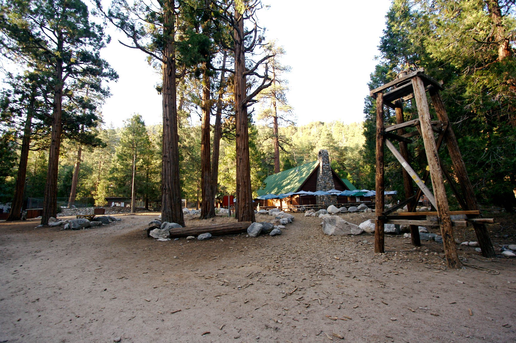
Overview to Camp Pine Mountain
Address: 43427 Highway 38, Angelus Oaks, CA 92305
To get to Camp Pine Mountain from Los Angeles area:
- Take I-10 to Redlands
- Exit University Ave and go north
- Turn right on Lugonia Ave. / Highway 38
- Turn right into Camp Pine Mountain
From UCLA, the drive usually takes 2-3 hours, depending on traffic.

Detailed Directions
- Take Interstate 10 East towards San Bernardino and Redland.
- In Redlands, take the exit for University Ave. This is about 2 miles east of the 210.
- Turn left onto University Ave.
- Turn right at the light onto Lugonia Ave (which is also called State Highway 38) after about 1.5 miles.
- This is a good time to check your fuel level. You will pass a sign that says “Next gas 45 miles” — this is the last gas station. Make sure you have enough fuel to get to camp and back. Driving uphill takes more gas than you might expect, so never go up the mountain without at least a half tank.
- Stay on Highway 38 for quite a while, about 25 miles. These landmarks can help make sure you stay on track:
- Landmark: Highway 38 will make a 180-degree left hand turn near the top of a valley with an opportunity to turn right (which can also look like going straight) to head to Forest Home. DO NOT TURN RIGHT!
- STAY LEFT and continue on Highway 38 as you make the 180-degree turn and climb the hill.
- Landmark: Stay on Highway 38 as you pass through the town of Angelus Oaks. You’ll see a store on your left.
- Landmark: Stay on Highway 38 as you pass Jenks Lake Road West on your right.
- Landmark: Stay on Highway 38 as you pass Glass Road on your left.
- Landmark: Stay on Highway 38 as you pass two “Mile High Pines Camp” signs on your left.
- Landmark: Stay on Highway 38 as you pass Greyback Amphitheater on your left.
- Begin slowing down once you see Greyback Amphitheater! Look for a “55mph speed limit” sign on the right side followed closely by a Camp Pine Mountain sign.
- Turn right into Camp Pine Mountain. Follow the short dirt road to the parking lot. (Drive SLOWLY down the dirt road. Going too fast can cause you to hit or kick up rocks that can pop your tire or bust your oil pan. UniCamp isn’t liable for any damage to your car on the road. You can prevent damage by taking the dirt road slowly.)
- If you pass the turnoff, you’ll see mailboxes on the left side, Jenks Lake Road East on the right, and then the road will begin going downhill. You’ll see South Fork Campground on the right side. If you see any of these, you’ve gone too far! Look for these landmarks in reverse.
- Welcome to Camp Pine Mountain! Please park your car near the others in the parking lot. Do not drive onto the campsite. Go to the lodge and ask for staff or leadership.
Mountain Driving
Driving in the mountains is significantly different from driving in the city. Here are some tips to help you make it to camp safely.
💧 Bring extra food/water/supplies. Road conditions can change suddenly, so always bring extra food, water, and emergency supplies (blankets, first aid kit, flashlight, etc.). Fill up your gas tank in Redlands, before heading up the mountain. Make sure your spare tire is inflated and in good condition.
🦌 Watch out for hazards. Scan the road and roadside for hazards. Animals, especially deer, can suddenly dart into the road. Rocks can fall into the road, especially on stretches next to steep slopes. Give bikers plenty of space when you pass them (at least 3 feet is required by law).
🚀 Let other cars pass you. The mountain road to camp has very few passing opportunities, so if a vehicle catches up to you, pull over at the nearest turn-out to let them pass you. (This is required by law in some cases.) Do not pass vehicles by crossing a double-yellow line. It’s customary to flash your hazard lights a few times to signal “thanks” if someone pulls over to let you pass.
⛈️ Check the weather and road conditions before driving. Click here to check current road conditions and click here to check the weather at camp. Weather at high altitude can be drastically different from what it is at the base of the mountain. If there’s any possibility of winter weather, carry chains.
📲 Bring offline directions. You will lose cell reception along the road. Bring a map, download directions offline, or print directions so you don’t get lost.
⤴️ Brake before sharp turns. Don’t wait until you’re into a turn to brake. Watch out for suggested corner speed signs to get an idea of how sharp a corner will be.
🏔️ Pulse your brakes and/or downshift when going downhill. When safe to do so, apply and release your brakes at regular intervals instead of “riding the brakes” to avoid overheating them. Consider downshifting to use engine braking when appropriate.
☃️ Current driving conditions (Updated 4/15/23) ☃️
Winter storms are common from November through April. Check weather and road conditions before you leave. Carry chains and watch out for snow/ice patches. Dirt roads can get muddy after a storm.
⚠️ Current driving conditions (Updated 6/14/24) ⚠️
Do not attempt to travel to Camp River Glen!
There was significant damage to the area from Tropical Storm Hilary in August 2023 that destroyed multiple roads and bridges. The conditions of the dirt roads leading to Camp River Glen are constantly changing and may be dangerous. Camp will not be held at River Glen in 2025.
Camp River Glen is located at 43191 Seven Oaks Road, Angelus Oaks, CA 92305. Click here to open the location in Google Maps. WARNING: Some mapping applications place the address in the wrong place, so always follow the directions below, even if you’re also using a GPS.
Do NOT rely on GPS or your phone to drive to camp! You WILL lose reception along the way and many apps have trouble with the mountain roads. Save, print, or screenshot these directions before heading to camp so you have them offline.
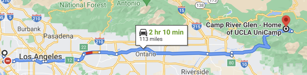
Overview (via Glass Road)
To get to Camp River Glen from Los Angeles area:
- Take I-10 to Redlands
- Exit University Ave and go north
- Turn right on Lugonia Ave. / Highway 38
- Turn left onto Glass Road
- Turn right onto 1N45
- Turn right into Camp River Glen after about 3 miles
From UCLA, the drive usually takes 2-3 hours, depending on traffic.
Detailed Directions
- Take Interstate 10 East towards San Bernardino and Redland.
- In Redlands, take the exit for University Ave. This is about 2 miles east of the 210.
- Turn left onto University Ave.
- Turn right at the light onto Lugonia Ave (which is also called State Highway 38) after about 1.5 miles.
- This is a good time to check your fuel level. You will pass a sign that says “Next gas 45 miles” — this is the last gas station. Make sure you have enough fuel to get to camp and back. Driving uphill takes more gas than you might expect, so never go up the mountain without at least a half tank.
- Stay on Highway 38 for quite a while, about 20 miles. These landmarks can help make sure you stay on track:
- Landmark: Highway 38 will make a 180-degree left hand turn near the top of a valley with an opportunity to turn right (which can also look like going straight) to head to Forest Home. DO NOT TURN RIGHT!
- STAY LEFT and continue on Highway 38 as you make the 180-degree turn and climb the hill.
- Landmark: Stay on Highway 38 as you pass through the town of Angelus Oaks. You’ll see a store on your left.
- Landmark: Stay on Highway 38 as you pass Jenks Lake Road West on your right.
- Turn left onto Glass Road. This is a paved road just before a small bridge. Keep going on the steep, windy decline for a few miles.
- Landmark: If you miss the road, you will see the Barton Flats Visitor Center on the right (then eventually Greyback Ampitheater and Jenks Lake Road East). If you see any of these, turn around and go back on Highway 38.
- Take the first right turn at the mailboxes onto USFS Road 1N45. This road will quickly transition into a dirt road. Keep going straight for about 3 miles and follow the road all the way to camp. You will pass two other camps (Camp Wasewagan then Camp Alandale) before crossing a one-lane bridge then going uphill. The entrance to Camp River Glen is about a quarter mile after the top of the hill.
- Drive SLOWLY down the dirt road. Going too fast can cause you to hit or kick up rocks that can pop your tire or bust your oil pan. UniCamp isn’t liable for any damage to your car on the road. You can prevent damage by taking the dirt road slowly.
- Turn right into Camp River Glen. The camp sign is facing the opposite direction so keep a close eye out for it.
- Landmark: The dirt road will split and a sign will say “Highway 38” pointing in both directions. If you see this, you’ve gone too far! Turn around on the dirt road (going away from the fork) and look for Camp River Glen on your left side.
- Welcome to Camp River Glen!
- Please do not drive your car across the bridge
- If parking: park in the lots on either side before the bridge, please reverse into your parking space (this is for fire safety), and walk across the bridge and go to the lodge. Ask for staff or leadership.
- If dropping off / picking up: follow UniCamp staff/volunteer directions.
Mountain Driving
Driving in the mountains is significantly different from driving in the city. Here are some tips to help you make it to camp safely.
💧 Bring extra food/water/supplies. Road conditions can change suddenly, so always bring extra food, water, and emergency supplies (blankets, first aid kit, flashlight, etc.). Fill up your gas tank in Redlands, before heading up the mountain. Make sure your spare tire is inflated and in good condition.
🦌 Watch out for hazards. Scan the road and roadside for hazards. Animals, especially deer, can suddenly dart into the road. Rocks can fall into the road, especially on stretches next to steep slopes. Give bikers plenty of space when you pass them (at least 3 feet is required by law).
🚀 Let other cars pass you. The mountain road to camp has very few passing opportunities, so if a vehicle catches up to you, pull over at the nearest turn-out to let them pass you. (This is required by law in some cases.) Do not pass vehicles by crossing a double-yellow line. It’s customary to flash your hazard lights a few times to signal “thanks” if someone pulls over to let you pass.
⛈️ Check the weather and road conditions before driving. Click here to check current road conditions and click here to check the weather at camp. Weather at high altitude can be drastically different from what it is at the base of the mountain. If there’s any possibility of winter weather, carry chains.
📲 Bring offline directions. You will lose cell reception along the road. Bring a map, download directions offline, or print directions so you don’t get lost.
⤴️ Brake before sharp turns. Don’t wait until you’re into a turn to brake. Watch out for suggested corner speed signs to get an idea of how sharp a corner will be.
🏔️ Pulse your brakes and/or downshift when going downhill. When safe to do so, apply and release your brakes at regular intervals instead of “riding the brakes” to avoid overheating them. Consider downshifting to use engine braking when appropriate.
Overview (via 1N45)
To get to Camp River Glen from Los Angeles area:
- Take I-10 to Redlands
- Exit University Ave and go north
- Turn right on Lugonia Ave. / Highway 38
- Turn left onto the dirt road, 1N45
- Turn left into Camp River Glen after about 2.5 miles
From UCLA, the drive usually takes 2-3 hours, depending on traffic.
Detailed Directions
- Take Interstate 10 East towards San Bernardino and Redland.
- In Redlands, take the exit for University Ave. This is about 2 miles east of the 210.
- Turn left onto University Ave.
- Turn right at the light onto Lugonia Ave (which is also called State Highway 38) after about 1.5 miles.
- This is a good time to check your fuel level. You will pass a sign that says “Next gas 45 miles” — this is the last gas station. Make sure you have enough fuel to get to camp and back. Driving uphill takes more gas than you might expect, so never go up the mountain without at least a half tank.
- Stay on Highway 38 for quite a while, about 27 miles. These landmarks can help make sure you stay on track:
- Landmark: Highway 38 will make a 180-degree left hand turn near the top of a valley with an opportunity to turn right (which can also look like going straight) to head to Forest Home. DO NOT TURN RIGHT!
- STAY LEFT and continue on Highway 38 as you make the 180-degree turn and climb the hill.
- Landmark: Stay on Highway 38 as you pass through the town of Angelus Oaks. You’ll see a store on your left.
- Landmark: Stay on Highway 38 as you pass Jenks Lake Road West on your right.
- Landmark: Stay on Highway 38 as you pass Glass Road on your left.
- Landmark: Stay on Highway 38 as you pass Greyback Ampitheater on your left.
- Landmark: Stay on Highway 38 as you pass Jenks Lake Road East on your right. On the left, is a row of mailboxes. This is the last landmark.
- About half mile after you pass Jenks Lake Road East and the mailboxes, at the bottom of a steep, windy decline, you’ll cross a small bridge and there is an open dirt area with a wooden fence and cabins on the left. TURN LEFT HERE! Look for a sign that says “Santa Ana River Trailhead” or “1N45”.
- Landmark: If you miss the turnout, you will see South Fork Campground on your right side and will cross over another small bridge. The turnout to camp is just before South Fork Campground on the left.
- Landmark: If you go even further past, will head uphill and pass by Heart Bar Campground on the right. If you see this, you’ve gone too far on Highway 38.
- Once you’ve made your turn onto USFS Road 1N45, keep straight and follow the road all the way to camp. There will be a few cabins on both sides of the road at the start.
- The road is not paved. (Drive SLOWLY down the dirt road. Going too fast can cause you to hit or kick up rocks that can pop your tire or bust your oil pan. UniCamp isn’t liable for any damage to your car on the road. You can prevent damage by taking the dirt road slowly.)
- Follow the dirt road for 2.2 miles down the river until you see the Camp River Glen sign on your left. You will cross the river twice on the road. TURN LEFT.
- Welcome to Camp River Glen!
- Please do not drive your car across the bridge
- If parking: park in the lots on either side before the bridge, please reverse into your parking space (this is for fire safety), and walk across the bridge and go to the lodge. Ask for staff or leadership.
- If dropping off / picking up: follow UniCamp staff/volunteer directions.
Mountain Driving
Driving in the mountains is significantly different from driving in the city. Here are some tips to help you make it to camp safely.
💧 Bring extra food/water/supplies. Road conditions can change suddenly, so always bring extra food, water, and emergency supplies (blankets, first aid kit, flashlight, etc.). Fill up your gas tank in Redlands, before heading up the mountain. Make sure your spare tire is inflated and in good condition.
🦌 Watch out for hazards. Scan the road and roadside for hazards. Animals, especially deer, can suddenly dart into the road. Rocks can fall into the road, especially on stretches next to steep slopes. Give bikers plenty of space when you pass them (at least 3 feet is required by law).
🚀 Let other cars pass you. The mountain road to camp has very few passing opportunities, so if a vehicle catches up to you, pull over at the nearest turn-out to let them pass you. (This is required by law in some cases.) Do not pass vehicles by crossing a double-yellow line. It’s customary to flash your hazard lights a few times to signal “thanks” if someone pulls over to let you pass.
⛈️ Check the weather and road conditions before driving. Click here to check current road conditions and click here to check the weather at camp. Weather at high altitude can be drastically different from what it is at the base of the mountain. If there’s any possibility of winter weather, carry chains.
📲 Bring offline directions. You will lose cell reception along the road. Bring a map, download directions offline, or print directions so you don’t get lost.
⤴️ Brake before sharp turns. Don’t wait until you’re into a turn to brake. Watch out for suggested corner speed signs to get an idea of how sharp a corner will be.
🏔️ Pulse your brakes and/or downshift when going downhill. When safe to do so, apply and release your brakes at regular intervals instead of “riding the brakes” to avoid overheating them. Consider downshifting to use engine braking when appropriate.
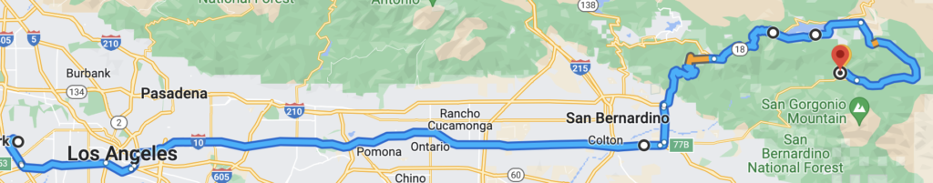
Overview (via 1N04)
To get to Camp River Glen from Los Angeles area:
- Take I-10 to Redlands
- Exit University Ave and go north
- Turn right on Lugonia Ave. / Highway 38
- Turn left onto the dirt road, 1N04
- Turn left into Camp River Glen after about 3 miles
From UCLA, the drive usually takes 2-3 hours, depending on traffic.
Detailed Directions
- Take Interstate 10 East towards San Bernardino and Redland.
- In Redlands, take the exit for University Ave. This is about 2 miles east of the 210.
- Turn left onto University Ave.
- Turn right at the light onto Lugonia Ave (which is also called State Highway 38) after about 1.5 miles.
- This is a good time to check your fuel level. You will pass a sign that says “Next gas 45 miles” — this is the last gas station. Make sure you have enough fuel to get to camp and back. Driving uphill takes more gas than you might expect, so never go up the mountain without at least a half tank.
- Stay on Highway 38 for quite a while, about 27 miles. These landmarks can help make sure you stay on track:
- Landmark: Highway 38 will make a 180-degree left hand turn near the top of a valley with an opportunity to turn right (which can also look like going straight) to head to Forest Home. DO NOT TURN RIGHT!
- STAY LEFT and continue on Highway 38 as you make the 180-degree turn and climb the hill.
- Landmark: Stay on Highway 38 as you pass through the town of Angelus Oaks. You’ll see a store on your left.
- Landmark: Stay on Highway 38 as you pass Jenks Lake Road West on your right.
- Landmark: Stay on Highway 38 as you pass Glass Road on your left.
- Landmark: Stay on Highway 38 as you pass Greyback Ampitheater on your left.
- Landmark: Stay on Highway 38 as you pass Jenks Lake Road East on your right. On the left, is a row of mailboxes.
- About half mile after you pass Jenks Lake Road East and the mailboxes, at the bottom of a steep, windy decline, you’ll pass by some cabins on your left, the South Fork Campground on your right, and then you’ll cross a bridge. Immediately after crossing the bridge, there will be an open dirt area on the left. TURN LEFT HERE! The dirt road begins at the easternmost end of this clearing. There are no signs.
- Note: If you see cabins, you are at the wrong turnoff! This road will not take you to River Glen!
- Landmark: If you go past the turnoff, the road will head uphill and pass by Heart Bar Campground on the right. If you see this, you’ve gone too far on Highway 38.
- Once you’ve made your turn onto USFS Road 1N04, keep straight and follow the road all the way to camp. After about a quarter mile, there will be a few cabins only on the left side of the road.
- The road is not paved. (Drive SLOWLY down the dirt road. Going too fast can cause you to hit or kick up rocks that can pop your tire or bust your oil pan. UniCamp isn’t liable for any damage to your car on the road. You can prevent damage by taking the dirt road slowly.)
- Follow the dirt road for about 3 miles down the river until you see the Camp River Glen sign on your left. TURN LEFT.
- The road will join in with another road alongside a sign saying “Highway 38” facing away from you. Keep going about another quarter mile.
- Landmark: If you come to the second fork in the road, you’ve gone too far. River Glen is about half-way between the two forks in the dirt road.
- Welcome to Camp River Glen!
- Please do not drive your car across the bridge
- If parking: park in the lots on either side before the bridge, please reverse into your parking space (this is for fire safety), and walk across the bridge and go to the lodge. Ask for staff or leadership.
- If dropping off / picking up: follow UniCamp staff/volunteer directions.
Mountain Driving
Driving in the mountains is significantly different from driving in the city. Here are some tips to help you make it to camp safely.
💧 Bring extra food/water/supplies. Road conditions can change suddenly, so always bring extra food, water, and emergency supplies (blankets, first aid kit, flashlight, etc.). Fill up your gas tank in Redlands, before heading up the mountain. Make sure your spare tire is inflated and in good condition.
🦌 Watch out for hazards. Scan the road and roadside for hazards. Animals, especially deer, can suddenly dart into the road. Rocks can fall into the road, especially on stretches next to steep slopes. Give bikers plenty of space when you pass them (at least 3 feet is required by law).
🚀 Let other cars pass you. The mountain road to camp has very few passing opportunities, so if a vehicle catches up to you, pull over at the nearest turn-out to let them pass you. (This is required by law in some cases.) Do not pass vehicles by crossing a double-yellow line. It’s customary to flash your hazard lights a few times to signal “thanks” if someone pulls over to let you pass.
⛈️ Check the weather and road conditions before driving. Click here to check current road conditions and click here to check the weather at camp. Weather at high altitude can be drastically different from what it is at the base of the mountain. If there’s any possibility of winter weather, carry chains.
📲 Bring offline directions. You will lose cell reception along the road. Bring a map, download directions offline, or print directions so you don’t get lost.
⤴️ Brake before sharp turns. Don’t wait until you’re into a turn to brake. Watch out for suggested corner speed signs to get an idea of how sharp a corner will be.
🏔️ Pulse your brakes and/or downshift when going downhill. When safe to do so, apply and release your brakes at regular intervals instead of “riding the brakes” to avoid overheating them. Consider downshifting to use engine braking when appropriate.
Overview (via Big Bear & 1N45)
To get to Camp River Glen from Los Angeles area:
- Take I-10 to Redlands
- Take the exit for Highway 210 North/West (towards Highland, the 330, and Big Bear)
- Exit right for Highway 330 North towards Big Bear
- Keep straight through Running Springs to join Highway 18 towards Big Bear
- Turn left onto Big Bear Blvd to stay on Highway 18
- Keep right to join Highway 38
- Turn right onto the dirt road, 1N45
- Turn left into Camp River Glen after about 2.5 miles
From UCLA, the drive usually takes 3-4 hours, depending on traffic.
Detailed Directions
- Take Interstate 10 East towards San Bernardino and Redland.
- In Redlands, take the exit for Highway 210 North/West towards Highland, Highway 330, and Big Bear. (This is the exit directly following Alabama St.)
- After about 4 miles, keep right to exit to Highway 330 towards Big Bear.
- After about 15 miles, as you go through Running Springs, keep left to stay on Highway 330 North towards Lake Arrowhead and Big Bear.
- Soon after, the road splits again: keep straight to join Highway 18 towards Big Bear Lake
- As you come into Big Bear, stay on Highway 18
- Turn left to stay on Big Bear Blvd. at the stoplight. Watch out for the arch across the road that says “The Village” to know where to turn.
- Stay on Highway 18 (aka Big Bear Blvd) through Big Bear.
- This is a good time to check your fuel level. Once you leave Big Bear, it’s another 45 minute drive to camp without any gas stations along the way. There are no gas stations near camp, so make sure you have at least half a tank of fuel before you leave Big Bear.
- As you exit Big Bear, take the lane that splits off to the right to join Highway 38.
- Stay on Highway 38 for about 17 miles. This will take you uphill initially then will start a gradual decline.
- Landmark: Onyx summit
- Landmark: Heart Bar Campground on your left
- Landmark: South Fork Campground on your left
- Directly after South Fork Campground, turn right onto the dirt road to join USFS Road 1N45 (there is a very small sign). There are cabins, a small wooden fence, some mailboxes, a sign that says “Santa Ana River Trailhead,” and an open dirt area.
- Landmark: If you start going on a windy uphill on Highway 38, see Jenks Lake Road, or see Greyback Ampitheater, you’ve missed the dirt road!
- Once you’ve made your turn onto USFS Road 1N45, keep straight and follow the road all the way to camp. There will be a few cabins on both sides of the road at the start.
- The road is not paved. (Drive SLOWLY down the dirt road. Going too fast can cause you to hit or kick up rocks that can pop your tire or bust your oil pan. UniCamp isn’t liable for any damage to your car on the road. You can prevent damage by taking the dirt road slowly.)
- Follow the dirt road for 2.2 miles down the river until you see the Camp River Glen sign on your left. You will cross the river twice on the road. TURN LEFT.
- Welcome to Camp River Glen!
- Please do not drive your car across the bridge
- If parking: park in the lots on either side before the bridge, please reverse into your parking space (this is for fire safety), and walk across the bridge and go to the lodge. Ask for staff or leadership.
- If dropping off / picking up: follow UniCamp staff/volunteer directions.
Mountain Driving
Driving in the mountains is significantly different from driving in the city. Here are some tips to help you make it to camp safely.
💧 Bring extra food/water/supplies. Road conditions can change suddenly, so always bring extra food, water, and emergency supplies (blankets, first aid kit, flashlight, etc.). Fill up your gas tank in Redlands, before heading up the mountain. Make sure your spare tire is inflated and in good condition.
🦌 Watch out for hazards. Scan the road and roadside for hazards. Animals, especially deer, can suddenly dart into the road. Rocks can fall into the road, especially on stretches next to steep slopes. Give bikers plenty of space when you pass them (at least 3 feet is required by law).
🚀 Let other cars pass you. The mountain road to camp has very few passing opportunities, so if a vehicle catches up to you, pull over at the nearest turn-out to let them pass you. (This is required by law in some cases.) Do not pass vehicles by crossing a double-yellow line. It’s customary to flash your hazard lights a few times to signal “thanks” if someone pulls over to let you pass.
⛈️ Check the weather and road conditions before driving. Click here to check current road conditions and click here to check the weather at camp. Weather at high altitude can be drastically different from what it is at the base of the mountain. If there’s any possibility of winter weather, carry chains.
📲 Bring offline directions. You will lose cell reception along the road. Bring a map, download directions offline, or print directions so you don’t get lost.
⤴️ Brake before sharp turns. Don’t wait until you’re into a turn to brake. Watch out for suggested corner speed signs to get an idea of how sharp a corner will be.
🏔️ Pulse your brakes and/or downshift when going downhill. When safe to do so, apply and release your brakes at regular intervals instead of “riding the brakes” to avoid overheating them. Consider downshifting to use engine braking when appropriate.